Welcome to Bushwalking in Brisbane Forest Park


This blog is devoted to the different walks I have completed in Brisbane Forest Park. Here I will share my photos and personal experiences, explaining the many different walks within the Park and some of the interesting features of each walk. Brisbane Forest Park is now known as the region of South D'Aguilar National Park, but for the purpose of this blog and my own connection and history with the Park, I still refer to it as Brisbane Forest Park.

Brisbane Forest Park lies northwest of Brisbane, at most an hour's drive from the CBD. The entire Park encompasses approximately 36,000 hectares of natural land and forest consisting of national park, recreational areas and tourist spots that attract day trippers, motorcyclists and those wishing to experience the magic of a rainforest retreat or just enjoy a getaway in the mountains.

The Park is full of interesting features such as creeks, rocky outcrops, mountains, waterfalls, plants, birds and other wildlife which makes it such a diverse and natural place to visit and enjoy.

The walks I will share in this Blog range from easy to quite challenging, but above all are fun to do. Please feel free to send me any of your comments.

Hope you like these as much as I did.

Happy walking :)

Wayne

Please note: The walks described within should be used as a guide only and carrying a topographic map, compass, water, food and a first aid kit is highly recommended when bushwalking. Only undertake walks within your own limits and fitness levels. Please be responsible by notifying a friend or family member before beginning any walk.
Showing posts with label England Creek (Left Branch). Show all posts

Tuesday, April 29, 2014

England Creek Bush Camp via Joyner's Ridge Road.


England Creek bush camp is located between two ridges, Joyner's Ridge Road and Lawnton Road, which extend westward from Mount Glorious Road. In conjunction with England Creek Road, this route is also known as the 'Aquila Loop' and is popular with both bushwalkers and mountain bike riders.

The walk along Joyner's Ridge Road to England Creek starts at the management road gate, adjacent to 'Miala' a busy picnic ground further along Mount Glorious Road. From here the walk to the bush camp is approximately 10kms and can be completed in about 3-4 hours, depending on rest stops and rate of travel. The start of the walk begins in a section of lush rainforest before opening up to sclerophyll forest, with spectacular views of the surrounding Park, including Northbrook mountain and further West towards Wivenhoe and Toowoomba. There are some interesting features along the walk including birdlife, rocky outcrops and a variety of plant species. Bellbirds can be heard echoeing their distinctive 'tinkling' sounds in the surrounding trees and Lace Monitors can often be spotted if not heard, rustling in the leafy undergrowth of the trees bordering the track.


The walk to England Creek is fairly easy going and the road gradually descends to the catchment below, however there are some uphill sections to negotiate just before the campsite is reached. It should be noted here that on return the ascent to Mount Glorious can become long and tiresome, especially when carrying a heavy backpack! After about 7kms or so, turn right (left turn will take you down to England Creek Right Branch. Please see other relevant posts on this Blog) at the intersection and follow 'England Creek Road' for about 1.5 hours. Mobile reception on the flat stretch of road just before you reach the campsite is relatively good here.


My friend and I recently camped here and upon arriving at the campsite, noticed it had been maintained since our last visit. Prior to this, the tent sites had been left in poor condition and were overgrown with weeds and there were some old rotting logs hastily arranged around a firepit. The condition of the campsite has dramatically improved since then and the old logs have been replaced with much larger logs sculpted into benches to sit on and there are two distinctive areas to pitch tents with minimal weed infestation. The creek crossing appears to have been severely damaged possibly by the 2010 flood, as part of the concrete slab has been washed a bit further downstream.
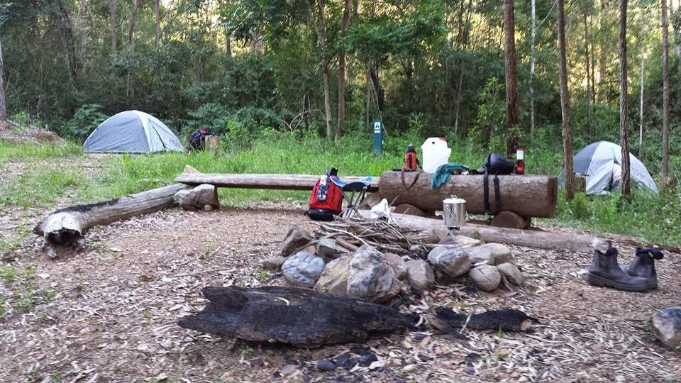

England Creek Bush Camp is for those looking for that authentic remote bush camping experience. After walking for a few hours the creek is immediately inviting and the campsite awaits for complete rest and relaxation. The night we stayed at the campsite it was very pleasant with very few mosquitoes and the temperature was mild and fairly comfortable at night, but a bit cooler the next morning. It wasn't cold enough to light a fire and also due to possible fire restrictions, we decided to use a portable gas stove and billy instead. Later that night we were greeted by some very bright stars (as well as an unexpected 'drive-by' from someone driving a Landcruiser - possibly a Park Ranger) and when the moon rose in the sky, the stars disappeared and the light from the moon cast an unusual 'glow' on the surrounding trees. The creek was quite low, however it was enough to take a dip, which was a great way to freshen up for the return walk the next morning!


What I think makes England Creek Bush Camp so memorable and unique is the location and the peaceful surroundings. The gentle, soothing sound of water running past in the creek lulled me straight off to sleep in my tent! A special place to camp and just take it all in.

Wednesday, December 23, 2009

England Creek (Left Branch) via Rocky Outcrop, Joyner's Ridge Road (map & compass required)


This walk is not only an alternative to the obvious and more easier route along England Creek and Joyners Ridge Roads, but also for those who wish to gain skills and confidence with orientation and map reading skills and prefer to go 'off track' and explore England Creek from a different perspective. The walk is a good test of agility and because of the rugged terrain, can be quite challenging at times.

From Joyner's Ridge Road walk approx 1.5hours (from the Mount Glorious end) until a rocky outcrop is found on the right. This is located on the BFP topographic map. From the rocky outcrop a bearing is measured by tracing a line on the map from the rocky outcrop to the crossing at England Creek. Adjust for magnetic variation.

Drop down from the rocky outcrop onto the spur below. This involves scrambling down rocks which are loose and can be dislodged quite easily. The spur is quite steep in descent and the ground is very loose underfoot, therefore it is not uncommon to stumble at least once on the way down!

Eventually a creek bed is found on the left hand side of the spur. Cross this creek bed and contour around to the next spur. Another creek bed is then found and crossed which eventually joins the first creek bed to become one creek. Drop down into this creek and rockhop all the way downstream until you reach the main branch of England Creek. Walk downstream for approx 10 -15 minutes and you will reach the crossing and campsite. To return, walk south up England Creek Road which eventually meets with Joyner's Ridge Road and back to Mount Glorious. Allow a full day for this walk.

Saturday, July 10, 2004

Joyners Ridge to Northbrook Parkway

This is a very long but picturesque walk through the centre of Brisbane Forest Park. Mobile reception is quite good for most of this walk, however this is limited once the Parkway is reached.

Take Joyner's Ridge Road and walk along it for approx 2.5 hours until the crossroads. This section is a nice walk through the Park, it is relatively flat and there are breathtaking views of the surrounding mountains and England Creek catchment area. Bellbirds can often be heard making their distinct 'tinkling' sound in the surrounding trees.

Once at the crossroads, turn right into England Creek Road which takes you down to the creek. This stretch of track will take about 2 hours but eventually you will reach the England Creek crossing and the 'campsite' beside the creek.

There is the opportunity to swim here, however when I visited here some years ago there was very little water in the creek, even after several days of rain. There are some waterholes along the creek, but once agin there may not be enough water in them or they are simply stagnant from lack of it. From the campsite the track starts to ascend, climbing the ridge up to Northbrook Mountain. This stretch is very long and tedious, but relatively easy to walk up.

Once at the top there is a deeply eroded track that drops steeply down the side of the ridge to Red and White Cedars. Alternatively, turn left at the top and follow Lawnton Road all the way, which will also take you down to the Parkway. This could be done either as a full day walk or ideally as a throughwalk, camping at the crossing of England Creek or at the campsite below Northbrook Mountain.