Welcome to Bushwalking in Brisbane Forest Park


This blog is devoted to the different walks I have completed in Brisbane Forest Park. Here I will share my photos and personal experiences, explaining the many different walks within the Park and some of the interesting features of each walk. Brisbane Forest Park is now known as the region of South D'Aguilar National Park, but for the purpose of this blog and my own connection and history with the Park, I still refer to it as Brisbane Forest Park.

Brisbane Forest Park lies northwest of Brisbane, at most an hour's drive from the CBD. The entire Park encompasses approximately 36,000 hectares of natural land and forest consisting of national park, recreational areas and tourist spots that attract day trippers, motorcyclists and those wishing to experience the magic of a rainforest retreat or just enjoy a getaway in the mountains.

The Park is full of interesting features such as creeks, rocky outcrops, mountains, waterfalls, plants, birds and other wildlife which makes it such a diverse and natural place to visit and enjoy.

The walks I will share in this Blog range from easy to quite challenging, but above all are fun to do. Please feel free to send me any of your comments.

Hope you like these as much as I did.

Happy walking :)

Wayne

Please note: The walks described within should be used as a guide only and carrying a topographic map, compass, water, food and a first aid kit is highly recommended when bushwalking. Only undertake walks within your own limits and fitness levels. Please be responsible by notifying a friend or family member before beginning any walk.

Saturday, September 13, 2014

Archer Campground, Mount Mee section


Archer campground is one of two camping areas located in the northern section of Brisbane Forest Park (D'Aguilar), more popularly known as Mount Mee. Archers has 9 campsites to choose from, each have a firepit and are situated beside a creek. The campground has toilet facilities and there is tank water usually available. Archers campground can be accessed via Woodford by car, access to Mount Mee is by 4WD only. The other campsite, Neurum Creek, has 13 campsites and is 6.3kms from the southern access to the Park (Mount Mee) or 13.5kms from the Northern access (Woodford). It can be easily confused with 'Neurum Bush Retreat' a privately owned and operated campground nearby.


'Broadwater' is a swimming hole situated not far from the campsite which has a toilet and a rest area.


Please note: There are no official graded walking tracks at Archers Campground. For more info on bushwalking and camping in Mount Mee, please copy and paste the following web links into your browser:

http://www.nprsr.qld.gov.au/parks/daguilar/pdf/mount-mee-trail-map.pdf

http://www.qld.gov.au

Sunday, July 13, 2014

Gold Creek Dam via Payne Road


This walk begins overlooking Enoggera Dam, off the Payne Road/Gap Creek Road roundabout at the Gap. It is about a 5 hour leisurely walk and access is via South Boundary Road, an unsealed management road which runs along a southerly ridge all the way to Mount Nebo. Being situated adjacent to a residential area, South Boundary Road is very popular with cyclists, runners, bushwalkers and those even riding on horseback. The road is mostly flat but has some hilly sections to negotiate along the way, however only moderate fitness is required. To access the Dam, simply walk along South Boundary Road for about 2 hours, then take the left turn off South Boundary Road immediately after reaching the overhead electricity pylons. It is then about a half hour walk down to the Dam.


The Dam has an unusual spillway which was damaged during floods in early 1890. It was replaced by an un-reinforced concrete stepped spillway, the first of its type in the world. Most of the 1890 concrete stepped spillway cascade is still in use.


The Dam is a great place to explore, with a number of footworn tracks to the right of and above the spillway. There are grassy areas below the Dam to sit and relax and just take it all in. Gold Creek Dam is very peaceful and scenic place to visit and enjoy and if travelling by car, vehicle access to the Dam is via Gold Creek Road from Brookfield.


It is also possible to walk all the way to Mount Nebo Road, or even undertake an overnight walk, camping at South Boundary Road at the corner of Scrub Road, then returning the following day. South Boundary Road is one of the main management roads in the Park and is an excellent access route for other bushwalking pursuits in D'Aguilar National Park.

For more information please go to the relevant postings on this site.

Tuesday, April 29, 2014

England Creek Bush Camp via Joyner's Ridge Road.


England Creek bush camp is located between two ridges, Joyner's Ridge Road and Lawnton Road, which extend westward from Mount Glorious Road. In conjunction with England Creek Road, this route is also known as the 'Aquila Loop' and is popular with both bushwalkers and mountain bike riders.

The walk along Joyner's Ridge Road to England Creek starts at the management road gate, adjacent to 'Miala' a busy picnic ground further along Mount Glorious Road. From here the walk to the bush camp is approximately 10kms and can be completed in about 3-4 hours, depending on rest stops and rate of travel. The start of the walk begins in a section of lush rainforest before opening up to sclerophyll forest, with spectacular views of the surrounding Park, including Northbrook mountain and further West towards Wivenhoe and Toowoomba. There are some interesting features along the walk including birdlife, rocky outcrops and a variety of plant species. Bellbirds can be heard echoeing their distinctive 'tinkling' sounds in the surrounding trees and Lace Monitors can often be spotted if not heard, rustling in the leafy undergrowth of the trees bordering the track.


The walk to England Creek is fairly easy going and the road gradually descends to the catchment below, however there are some uphill sections to negotiate just before the campsite is reached. It should be noted here that on return the ascent to Mount Glorious can become long and tiresome, especially when carrying a heavy backpack! After about 7kms or so, turn right (left turn will take you down to England Creek Right Branch. Please see other relevant posts on this Blog) at the intersection and follow 'England Creek Road' for about 1.5 hours. Mobile reception on the flat stretch of road just before you reach the campsite is relatively good here.


My friend and I recently camped here and upon arriving at the campsite, noticed it had been maintained since our last visit. Prior to this, the tent sites had been left in poor condition and were overgrown with weeds and there were some old rotting logs hastily arranged around a firepit. The condition of the campsite has dramatically improved since then and the old logs have been replaced with much larger logs sculpted into benches to sit on and there are two distinctive areas to pitch tents with minimal weed infestation. The creek crossing appears to have been severely damaged possibly by the 2010 flood, as part of the concrete slab has been washed a bit further downstream.


England Creek Bush Camp is for those looking for that authentic remote bush camping experience. After walking for a few hours the creek is immediately inviting and the campsite awaits for complete rest and relaxation. The night we stayed at the campsite it was very pleasant with very few mosquitoes and the temperature was mild and fairly comfortable at night, but a bit cooler the next morning. It wasn't cold enough to light a fire and also due to possible fire restrictions, we decided to use a portable gas stove and billy instead. Later that night we were greeted by some very bright stars (as well as an unexpected 'drive-by' from someone driving a Landcruiser - possibly a Park Ranger) and when the moon rose in the sky, the stars disappeared and the light from the moon cast an unusual 'glow' on the surrounding trees. The creek was quite low, however it was enough to take a dip, which was a great way to freshen up for the return walk the next morning!


What I think makes England Creek Bush Camp so memorable and unique is the location and the peaceful surroundings. The gentle, soothing sound of water running past in the creek lulled me straight off to sleep in my tent! A special place to camp and just take it all in.

Sunday, December 30, 2012

Dundas Road circuit walk via Goodes Road

This walk begins at the Mount Nebo Transfer Station and returns via a fire break. It should be noted here that this walk should only be undertaken by experienced bushwalkers, as there are some steep sections to negotiate up until Goodes Road.

Walk twenty minutes or so to the Dundas Road campsite and at the crossroads, do not detour but continue walking straight ahead along Dundas Road. About half an hour or so you will reach a fork in the road and a D'Aguilar Park sign, marking the region of Cabbage Tree Range. Take the right fork in the road and shortly after you will come to a gate. Turn right and begin descent down the fire break. The break has some very loose gravel and is very steep in sections, so extreme care is required until you reach the creek below. Allow at least a good half hour to an hour for descent.

At the creek the track picks up again and climbs steeply up the range. This section requires very good fitness. At the top the track widens to become Goodes Road. There are some great views here of the surrounding Park.


Be sure to turn right not left after you reach the pylons. Follow the remaining track which is an easy walk back to the campsite. Allow at least 3 hours to complete this walk.

Sunday, November 18, 2012

Branch Creek via Cabbage Tree Range


This walk begins from behind the Mount Nebo Transfer station off Mount Nebo Road and includes the catchment area around Lake Manchester. This walk overall is not difficult but is rather long and can prove tiresome with some ascent required upon return. There are a number of hiking trails and explorative opportunities along this walk so a topographic map is recommended but not essential, as the routes described are well signposted.

Follow Dundas Road for approx 20 mins until you reach the campsite and crossroads. Take Cabbage Tree Range road and follow this for about 2 hours down to the upper section of Branch Creek. There is a few options to consider here; either take the much shorter "Job 6 Break" road back up to Light Line Road,which is also known as the "Cabbage Tree Range loop." There is also the opportunity to camp at the Light Line Road camping site or simply cross the creek and follow Branch Creek Road to Lake Manchester and stay overnight at the campsite there instead. I returned the same way I walked down to Branch Creek which I found a bit tiresome, being mostly an uphill climb back to Dundas Road, so it may be more ideal to do the Loop walk and leave another car at the gate, at the end of Forestry Road in Mount Nebo.

Another idea is for two walking parties to take two seperate cars, one group drive to Lake Manchester and the other park at the gate at Dundas Road. Both parties walk in towards each other and meet at Branch Creek.

Sunday, July 29, 2012

Lake Manchester circuit walk


Lake Manchester is a water catchment facility situated in the south-western corner of Brisbane Forest Park (D'Aguilar National Park) It lies just North of Ipswich on the outskirts of Kholo. To get to Lake Manchester, simply follow Lake Manchester Road which is mostly sealed road.


Lake Manchester Dam was completed in 1916 and named after Mr E.J. Manchester, president of the Metropolitan Water Supply and Sewerage Board. Originally the Dam was called "Cabbage Tree Creek Dam." The Dam was reactivated in 2005 when the Brisbane drought was at a critical point and upgraded in 2007 for security and safety purposes.


Lake Manchester provides popular leisure activities such as bushwalking, mountain biking, horse riding and bush camping. There are a number of interesting features such as views of the Lake and surrounding mountains, including the peaks and ranges outside Ipswich. Cabbage Tree Creek and Branch Creek flow into Lake Manchester and are quite pleasant to visit.


The circuit walk is approximately 17km long and was completed in just over 5 hours. It begins at the car park and crosses the creek downstream from the Dam wall. The walk is accessed by a vehicular dirt track that winds it's way through bushland and traverses the surrounding foothills and ranges of Brisbane Forest Park. The route intersects with other Park Management roads, including Branch Creek Road and Light Line Road. There are many routes to consider therefore explorative opportunities in this region are virtually endless.


From the map at the carpark it is easy to assume this walking trail concludes at the car park, however it actually ends up at the T-intersection of Lake Manchester and Kholo Roads, therefore the remaining part of the walk is along bitumen road to get back to the car park. Overall the walk is fairly easy going, however there are some creek crossings to negotiate and steep sections of the track that can be tiresome. It is best completed in a clockwise direction, the route described is as follows:
"North Lake Manchester Road" - "Light Line Road" - "South Lake Manchester Road".

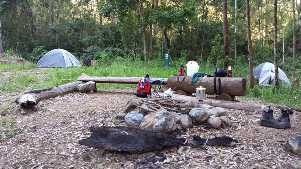
Other walks from BFP that connect Lake Manchester, among others, are via "South Boundary Road" and "Cabbage Tree Creek Road"(please refer to relevant posts on this site). To access the bush campsite, walk anti-clockwise starting at the T-intersection of Lake Manchester and Kholo Road and walk for approximately 6kms until you reach the campsite and Cabbage Tree Creek. For the first 100 metres or so the track is heavily eroded and extremely muddy.

The circuit route described is well signposted, however a map is recommended to assist with orienteering your desired route and calculating rate of travel. For those who want do a shorter walk but do not wish to complete the full circuit, simply follow North Lake Manchester Road for a few kilometres, then take one of 3-4 diversions that turn left from the main track. These meet with Cabbage Tree Range which eventually leads back to the carpark. If completing the full circuit, allow a full day for rest breaks and to explore the surrounding area.

Saturday, March 17, 2012

Cabbage Tree Creek via South Boundary Road (circuit walk)

This walk explores the catchment area around Lake Manchester and was completed as a circuit walk, starting at the Mount Nebo end of South Boundary Road. It is approximately 17km in total and requires some basic map reading skills to track progress. It is not 'hard' in the bushwalking 'scheme of things,' however it is quite a long walk and there is some endurance required, therefore I have classified the walk as 'Moderate to Difficult.'

Follow the track from Mount Nebo for about 1.5km then turn right into Augies Road, following this downhill. After about an hour or so you will reach a water tank on the right, then a T-junction. Turn right here and descend to the main branch of Cabbage Creek. There are numerous creek crossings along this stretch of the track which may be difficult to cross if the creek is flowing well, however did not present any problem when I visited earlier this year. Several kilometres south the creek widens and meets with Lake Manchester.

Upon ascent, turn right at the T-junction into Creek Road which leads downhill to the East branch of Cabbage Tree Creek. After the creek crossing it is a relatively steep climb back to South Boundary road. There is also the option to camp at the intersection of Scrub Road and South Boundary Road after completing this walk. For more info on South Boundary Road, please refer to similar posts on this site.

An alternative walk is to start at Mount Nebo, finishing at Lake Manchester,two cars left at either end of the walk. There is also the opportunity to explore surrounding areas such as Mermaid Mountain and Gold Creek.


Wednesday, January 18, 2012

South Boundary Road to Jolly's Lookout (circuit walk)

This walk is an alternative to the circuit walks around "Boombana" and for those who wish to explore the surrounding area and don't mind the idea of walking off-track. Long pants and a long sleeve shirt would be recommended due to the 'scratchy' nature of this terrain.

The walk begins at South Boundary Road. After walking approx. 1.5kms turn sharp left. (opposite turnoff to Augies Road) where the remnants of an old track can be found. It is easygoing at first but then overgrown along sections. There are some obstacles to negotiate along the way,such as fallen trees and some lantana, but hopefully this will not deter exploration only thwart progress.

It is a great 'starter' walk for those wishing to get used to off-track walking, with the feeling you are safe following a track. It's also an ideal way to practice some basic bush navigation. The region of D'Aguilar Range is abundant with plant and animal life and is an interesting place to explore. Within a short space of time I observed a Lace Monitor, Wallaby, Green Tree snake and a rather angry and surprised Carpet Python which I nearly stepped on!

The track winds it's way through different vegetation types and crosses two tributaries of Enoggera Creek. A map and compass are required to locate the circuit track near Jolly's lookout, which virtually 'touches' the edge of the track on the BFP topographic map. Once located this can be followed to Jolly's Lookout or Boombana, the latter eventually intersecting with South Boundary Road.

Alternatively, continue along the track towards Mount Nebo Road. At the time of descent there was severe Lantana infestation on either side of the track, however the route was feasible. This is a very eroded and steep section to negotiate and stinging nettle can be found at the bottom of the track near Mount Nebo road, so care is required. Once at the creek crossing, simply walk up to the road and walk back towards Jolly's Lookout.

Sunday, December 4, 2011

Love Creek Falls

There are a number of different ways to access Love Creek Falls, however the most obvious route will only be explained in this post. Only confident bushwalkers should attempt this walk as there are a number of waterfalls to negotiate along the creek, therefore experience with rock scrambling is essential. This walk can be quite slow and challenging due to the slippery nature of the terrain, so extreme care should be taken at all times.

Turn right onto Alex Road about 1km or so from Mount Glorious and at the car park, simply descend into the creek and follow it all the way downstream. There are a number of watefalls, rock pools and interesting palm groves along the creek which flows well after prior rain. Once at the falls, there are breathtaking views of the valley below. For those willing to explore the surrounding area, there are a number of other routes to consider that follow old logging trails which connect with Greene's Falls and Maiala picnic ground.

Tuesday, August 16, 2011

A collection of plant species in Brisbane Forest Park

I studied Horticulture a few years ago, so being into all things bushwalking I decided to compile a list of plants that I have on occasion observed while I have been exploring in Brisbane Forest Park. I guess I kinda felt like putting this up on my Blog to rekindle my interest and love of plants that I have, like so many other things from time to time, put aside or forgotten about being so busy!

This list is growing, watch this space for more photos once I have put them up...


Stinging tree
(Dendrocnide excelsa - also known as Laportea gigas)
(Dendrocnide moroides - also known as Laportea moroides)


Bird nest
(Asplenium nidus)


Cunjevoi
(Alocasia brisbanensis)
(Alocasia macrorrhizos)


Staghorn fern or Elkhorn
(Platycerium bifurcatum)


Grass Tree
(Xanthorrho​ea)


Australian Fan Palm or Cabbage Palm

(Livistona Australis)